The World’s Highest Bridge Explained
How China Built a Structure That Redefined What a Mountain Crossing Can Be
For decades, the Huajiang Canyon stood as a natural barrier that shaped daily life across this region of southwest China. Communities on opposite sides of the valley lived almost as separate worlds. A simple trip between them could take hours. Narrow mountain roads clung to steep cliffs, and a single rockslide or fog bank could shut down travel without warning. I remember my first time studying this landscape on satellite maps and feeling how unforgiving it truly was.
Solving this problem demanded something far bolder than another road or a deeper tunnel. Engineers decided to cross the void itself. The answer became a suspension bridge positioned 625 meters above the canyon floor, in one of the most geologically unstable regions in Asia.
Also Read: Can Floating Cities Save Humanity from Rising Seas?
A Bridge That Redefines What Should Be Possible
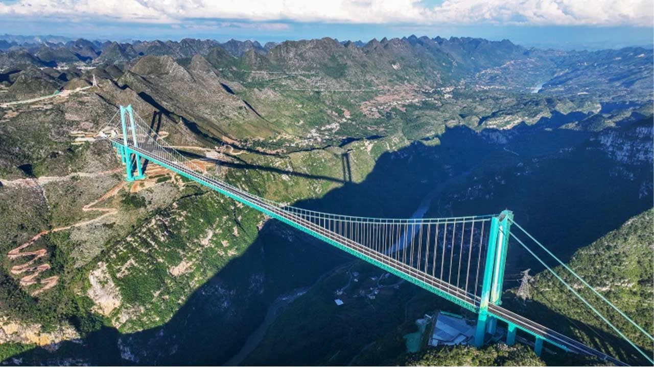
The Huajiang Bridge hangs so high over the Beipan River that standing on the deck feels like stepping off the roof of one of China’s tallest towers. Powerful winds cut through the valley below. The mountains around it shift over time. Ground layers tilt and fracture in unpredictable ways. Everything about this environment challenges the idea of building anything permanent here.
Engineers chose to do it anyway. And in the process, they created the highest bridge on Earth, a structure that demonstrates the level of ambition driving China’s inland infrastructure program.
Guizhou: A Region Both Beautiful and Isolated
The bridge rises in Guizhou Province, a place with dramatic scenery shaped by deep valleys, folded peaks, and karst formations. More than ninety percent of the province is mountainous. Locals often say you cannot find three feet of flat land anywhere. From above, the terrain resembles a green maze. That beauty came with a human cost. Generations of people lived with limited access to larger cities, stable markets, and hospitals simply because there was no reliable way to cross these mountains.
By the early 2010s, this isolation had turned into a national development concern. China decided to address it directly. Beginning around 2012, the government launched one of the world’s largest inland infrastructure initiatives. The goal was simple: connect remote regions to the national economy.
Guizhou became the epicenter of this effort. The province gained new airports, expressways, and fast rail connections. Most striking was the sheer number of bridges. More than thirty thousand new crossings were built across valleys, rivers, and ridges. Each structure shortened travel time, made goods cheaper to move, and tied neglected towns to stronger economic corridors.
Among all these projects, the Huajiang Canyon stood as one of the last major barriers left to solve.
A Canyon That Forced Engineers to Think Differently
Before the bridge, travelers needed nearly two hours to navigate the mountain roads that curled around the canyon. Drivers faced tight bends, unpredictable fog, and steep drops that demanded constant caution. The solution became part of the S57 Expressway, a 150-kilometer highway designed to connect communities through tunnels, cuttings, and elevated structures.
Crews blasted through rock walls and excavated a V-shaped corridor across part of the mountain range. And at the center of this new expressway, they placed the Huajiang Bridge: a span of 2,890 meters in total length, with a 1,420-meter main span suspended above terrain so deep that the canyon floor appears almost unreachable.
When it opened in early 2024, the bridge claimed a world record for height, pushing bridge engineering into territory rarely attempted before.
Why This Bridge Could Not Use a Conventional Design
Spanning a canyon of this depth forced engineers to make choices that balanced risk, flexibility, and the geological limits of each tower location. Cable-stayed designs were evaluated, but the height and span exceeded safe boundaries for that approach. A classic suspension bridge offered better reach, but only if the anchors could grip into stable rock.
Engineers settled on a steel truss suspension design. This approach provided a blend of strength and adaptability. The truss stiffens the roadway against wind, while the suspension cables carry the load across the open gap. The design also works well in steep terrain where bedrock can handle enormous tension forces.
Before committing to the final plan, survey teams studied a ten-kilometer section of the canyon in both directions. They mapped fault lines, measured rock conditions, analyzed wind patterns, and tested tower locations. That data shaped the bridge’s asymmetrical form. Canyon width restricted where crews could place towers. Foundation depth dictated tower height. Elevation introduced forces rarely encountered at these scales. Each constraint guided the design toward a unique balance of strength and flexibility.
Digital Construction for a Structure in Open Air
Nothing about this bridge could rely on traditional equipment. The canyon is simply too deep. No crane on Earth can reach the bottom, and even if one could, accessing the base of the valley would have slowed the project beyond reason. Instead, engineers built an overhead cable crane system that worked like an aerial railway. It carried steel components across the void with precision and stability.
The bridge consists of ninety-three steel truss segments weighing a combined twenty-two thousand tonnes. For perspective, that is roughly three times the amount of steel used in the Eiffel Tower. Engineers digitally assembled the entire bridge before any physical work began. Every bolt, cable, and joint was modeled to predict real-world behavior. On site, crews relied on the BeiDou satellite navigation system to position steel segments with millimeter accuracy. One misalignment could have set thousands of tonnes swinging high above the canyon.
That level of precision speaks to the complexity of building at this height. You can almost imagine what it felt like to stand on the temporary catwalks, watching steel move through the air against a backdrop of cliffs and clouds.
Adapting to an Uneven and Unstable Landscape
The canyon walls slope differently on each side, so the towers could not match in height or structure. The north tower rises 262 meters, built atop deeper, stronger rock. The south tower reaches 205 meters and relies on a different anchoring system suited to its geology. Engineers embraced asymmetry because nature demanded it.
This region also experiences regular seismic activity. To protect the bridge, designers treated it like a massive pendulum capable of moving with controlled freedom. Shock absorbers help dissipate energy from earthquakes or temperature shifts. The bridge can sway without transferring destructive forces to the towers or cables.
Wind posed another major challenge. The canyon amplifies wind speed much like a nozzle speeds up water flow. Engineers tested scale models in wind tunnels and ran advanced simulations to understand how the bridge would react. Today, Doppler LiDAR systems track airflow in three dimensions, providing real-time data on gusts and turbulence.
A Smart Bridge That Watches Itself
The Huajiang Bridge does not rely only on inspections. Fiber-optic sensors embedded in the structure continuously measure strain, temperature changes, vibrations, and cable tension. These readings help predict maintenance needs long before any visible issue arises. The suspension cables use pre-formed parallel wire strands that deliver high strength and durability. Any unusual movement triggers alerts so engineers can respond immediately.
Maintaining a bridge at this height requires a new approach to access. Crews work from elevated walkways positioned above the roadway. This is a level of vertical exposure that earlier generations of bridge builders never had to consider. Human access has shifted into the sky.
A Project That Reshapes an Entire Region
The Huajiang Bridge cost around 300 million dollars and took three and a half years to complete. Those numbers highlight China’s construction capacity. The country already leads the world in high-speed rail length, large-scale bridges, and water engineering. Huajiang is part of the system that enables China to build with remarkable speed.
The bridge carries economic importance as well. Remote communities now link directly to regional and national markets. Travel times collapse. New business routes open. The structure also aligns with China’s broader economic outreach strategy, strengthening inland trade connections that complement Belt and Road corridors.
Turning a Mountain Crossing into a Destination
Beyond its practical role, Huajiang is being shaped into a tourism hub. Plans include a glass elevator rising through the canyon, a two-level café inside one of the towers, a glass walkway beneath the deck, and high-altitude adventure platforms. Guizhou officials also proposed a large artificial waterfall and spaces for extreme sports that draw visitors seeking the thrill of height.
These additions reflect a larger trend in modern infrastructure. Bridges are no longer only about crossing a gap. They create identity, attract visitors, and support the local economy in ways that extend far beyond transportation.
Also Read: Inside Naypyidaw: The $7 Billion Ghost Capital of Myanmar
A New Standard for Mountain Engineering
The Huajiang Bridge stands today as a physical and symbolic marker of what determined engineering can achieve. It joins technical strength with regional development and a vision for tourism that rises directly from the landscape. Walking across it or even seeing it from a distance makes you feel how far engineering has come. You sense the ambition behind it and the confidence of the teams who built it.
This structure proves that mountains are no longer barriers. They are canvases for a new kind of infrastructure that weaves human movement through some of the most dramatic terrain on Earth.