China’s $70 Billion Water Transfer Project and the Battle to Move Rivers
China moves more water across its territory than any nation in history. Every year, engineers divert more than 44.8 billion cubic meters of freshwater from the humid south toward the thirsty north. I stood near one section of the canal system during research and watched water flow through artificial riverbeds carved into the countryside. The scale felt unreal.
This effort bears the official name South to North Water Transfer Project. Engineers designed it as a 3,000-kilometer national water corridor stretching from the Yangtze River basin to Beijing, Tianjin, and the industrial heartlands of northern China. Public estimates place the total investment above $70 billion, with infrastructure costs continuing to rise as upgrades accelerate. The project has already forced the relocation of more than 330,000 residents and permanently reshaped rural landscapes across multiple provinces.
China pursued this vision out of necessity rather than spectacle. Northern China contains nearly 45 percent of the population and most of the heavy industrial economy, yet the region holds less than 20 percent of China’s freshwater supply. Decades of groundwater overpumping dried aquifers across Hebei, Shanxi, and Inner Mongolia. In many northern cities, land subsidence reached dangerous levels. Building collapses and cracking roads emerged as visible warnings of a growing crisis.
Authorities could no longer treat the water shortage as a regional inconvenience. Beijing framed the project as a matter of national security. They aimed to sustain agriculture, industry, and megacity growth by physically relocating water from the southern river networks that overflow during monsoon seasons.
This decision revived an idea first voiced in 1952, when Mao Zedong observed the national imbalance and suggested that the south could “lend water to the north.” That statement matured into a massive, decades-long public works strategy. Design studies continued through the late 20th century. Construction began in the early 2000s. Water finally started flowing in stages after 2013.
Also Read: Africa’s Game-Changing Dam: Inside the $4.5B Mphanda Nkuwa Hydropower Project
A Country Divided by Water
Southern China sits atop the Yangtze and Pearl River basins. Seasonal floods devastate farmlands and cities there with painful frequency. Northern China depends on short rivers that often fail to reach the sea. Groundwater historically filled the gap, but decades of pumping caused dramatic depletion.
In Hebei Province alone, groundwater extraction exceeded natural recharge by billions of cubic meters annually for over three decades. Land subsidence across parts of the North China Plain reached more than two meters in some districts, according to the Chinese Academy of Sciences. Wells deepened each year. Salinity increased. Crop yields suffered.
You can walk through old villages outside Beijing where abandoned hand-pump wells now stand next to dry canals. The water shortages forced millions to accept rationing programs and escalating utility costs before the transfer project even opened.
The Eastern Route and the Revival of the Grand Canal
The Eastern Route follows much of the 2,500-year-old Grand Canal, once the lifeline of imperial commerce. Engineers converted it into a water pipeline stretching 1,000 kilometers north from the Yangtze near Yangzhou.
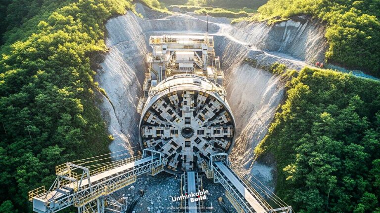
Twenty-three massive pumping stations elevate the water step-by-step across varying terrain. Engineers also tunneled beneath the Yellow River, threading water through one of the most sediment-heavy riverbeds on the planet. That underground crossing required slurry shield tunnel boring machines capable of operating in unstable flood sediments.
Water reached Shandong Province in 2014. Tianjin followed shortly after. The line now provides water access to over 10 million residents and growing industrial zones.
Pollution created an early crisis. Industrial runoff, fertilizer discharge, and aging wastewater treatment left the canal contaminated. Before any water entered the North China Plain, engineers upgraded or constructed hundreds of treatment plants, sealed canal beds, and established protective wetlands to filter runoff.
Even now, constant monitoring detects chemical spikes that force temporary diversion closures. Moving water does not remove what flows within it. Engineers must treat the river as a living system rather than a passive pipe.
The Central Route and Gravity Engineering
The Central Route remains the most technically elegant and socially disruptive portion. It originates from the Danjiangkou Reservoir on the Han River, a Yangtze tributary. The canal runs 1,267 kilometers northward toward Beijing entirely by gravity.
Surveyors mapped precise elevation changes with centimeter accuracy to maintain natural flow. Water descends slowly without pumps, using only terrain slope and hydraulic balancing structures.
Beijing now sources nearly one-third of its drinking water from this single route. Lakes refilled after years of desiccation. Urban aquifer levels stabilized. Municipal water quality improved measurably according to Chinese Ministry of Water Resources reports from 2019 through 2024.
The human price proved severe. Reservoir expansion submerged communities across Hubei and Henan provinces. More than 330,000 residents relocated, many forced to abandon ancestral farmland. Compensation programs financed apartment developments, but cultural displacement remains unresolved. Several resettlement towns struggle with unemployment and declining agricultural productivity.
Environmental impacts also persist downstream. Reduced Han River flows affect fisheries and irrigation. To counter this, researchers proposed a long-dormant transfer tunnel linking the Three Gorges Reservoir to the Han River basin. Feasibility studies remain active as of 2025, with early geological surveys signaling enormous engineering risk due to unstable strata and seismic exposure.
The Western Route and International Risk
The final phase exists only as concept plans. The Western Route proposes tunnels through the Tibetan Plateau to divert headwaters from rivers including the Mekong, Salween, and Brahmaputra toward the Yellow River basin.
This strategy triggers geopolitical concerns. These rivers sustain hundreds of millions across Southeast Asia and South Asia. India, Vietnam, Laos, Myanmar, and Cambodia depend on stable flows for agriculture and hydropower. Any upstream control threatens diplomatic rupture.
Engineering challenges mount as well. Tunneling beneath 5,000-meter elevations in earthquake-active zones presents extreme hazards. Rock instability, glacial meltwater infiltration, and unpredictable seismic load complicate reliability predictions.
Chinese authorities have not approved construction as of 2025. The route remains under “strategic evaluation” status, signaling long-term uncertainty and sustained debate.
Economic Impact and Uneven Benefit
Urban residents have reaped the greatest gains. Beijing stabilized water pricing. Tianjin ended rationing cycles that plagued manufacturing districts. Industrial production recovered seasonal reliability.
Rural communities near the canals often experience exclusion. Water flows past villages without connection infrastructure. Farmers still rely on depleted groundwater because pipeline extensions remain financially impractical. Evaporation losses across uncovered canal sections reduce transported volume by millions of cubic meters annually.
Some analysts argued that desalination plants, aggressive infrastructure leak repairs, or mandated industrial water recycling would have reduced costs and social displacement. China pursued all three strategies but at scales smaller than the transfer system itself.
Desalination currently supplies only about 3 percent of northern urban demand. Leakage reduction programs lowered city losses but could not meet total need. Industrial recycling expanded but failed to stabilize agricultural irrigation alone.
Smarter Controls and System Upgrades
China now retrofits the project with digital flow control, real-time pollution sensors, and satellite monitoring. The Central Route alone integrates 60 check gates and 90 diversion hubs coordinated through centralized management centers.
Engineers model weather effects and sediment buildup to anticipate stress points. Response times dropped sharply during contamination events since system automation deployment in 2022.
Canal covering programs have begun pilot studies to reduce evaporation, though full enclosure proves cost prohibitive across long distances.
The structure no longer operates as a simple canal network. It functions as a coordinated hydraulic grid governed by data analytics and continual monitoring.
Climate Uncertainty and Supply Risks
Climate change introduces a destabilizing variable. Southern China experienced historically low Yangtze water levels between 2022 and 2024, affecting both shipping and hydropower output. Himalayan glacier retreat alters long-term river discharge patterns feeding western headwaters.
Reduced southern supply could constrain water exports northward, forcing renewed groundwater pumping cycles or urban restriction programs.
China moved rivers, yet the rivers themselves face unpredictable transformation.
If supply contraction continues, the project may maintain only partial operational capacity without supplemental sources.
Also Read: World’s Largest Crane Ships: Giants That Lift 15,000 Tons at Sea
A Nation’s Gamble Against Nature
The South to North Water Transfer Project ranks as the largest hydraulic manipulation ever completed. Over 3,000 kilometers of canals and tunnels operate continuously across multiple terrains. More than $70 billion funded construction. Hundreds of thousands of lives shifted permanently because of its execution.
I studied this system not just on maps but onsite, and you feel the quiet tension that lingers around it. The water moves endlessly north, but the risks never stop moving with it.
China achieved an engineering miracle. It also created a long-term wager against climate shifts, environmental balance, and geopolitical stability. The project rescued northern cities from immediate crisis, yet it binds their future to fragile southern watersheds.
The unanswered question remains simple but heavy. Can human ambition truly overpower hydroclimatic uncertainty, or will nature demand another, even costlier response in the decades ahead.